Monday, October 1, 2012

New Zealand- South Island


Little Blue Penguins

Last week we had an eight day trip around the South Island of New Zealand with Jenny's parents and aunt Sharon. Here are some brief highlights of our trip. 

Day 1. Christchurch to Oamaru.

We arrived into Christchurch, picked up our hire car, and immediately headed southwest down the coast to Oamaru. We arrived just in time to watch the nightly parade of the Little Blue Penguins in from the ocean at the Oamaru Blue Penguin Colony. They were hilarious to watch and we were fortunate to see over 100 march in that evening. They are the world's smallest penguins and are found throughout coastal New Zeland and southern regions of Australia.We weren't able to take any photos of the penguins but here is an image I found online

Jenny & Sharon
Day 2. Oamaru to Manapouri. 

We continued driving south along the coast and stopped to check out the Moeraki Boulders (near Moeraki). We were fortunate enough to have a low tide to fully appreciate and walk around the rocks (otherwise they would be submerged) and that the rain held off while we were on the beach. The Moeraki Bolders are very spherical rocks, like giant marbles. Here are few photos including one with a cracked open boulder (at left).
Jenny with her parentsWe also stopped at a small cheese factory, Evansdale Cheese, and purchased some excellent cheeses en route to Dunedin where we purchased groceries and some supplies. It was lightly raining and we had our lunch not far from the beach outside town but it was extremely windy and quite cool so most of us just ate in the vehicle. We continued our drive passing through Balclutha, and Gore on our way to Manapouri (just south of Te Anau) where we spent the next two nights. We drove by a lot of farms, sheep with their little lambs, dairy cows, beef, deer, and elk.

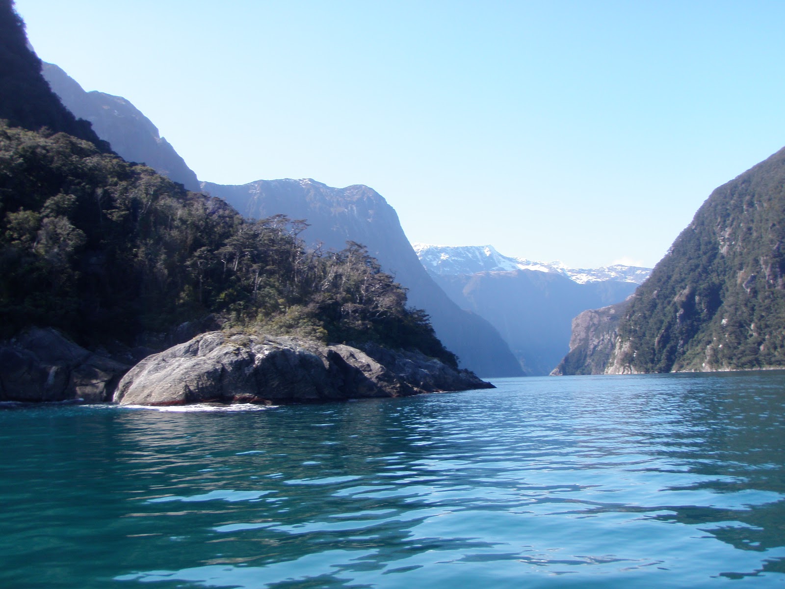
Day 3. Milford Sound and Te Anau.

We headed out early in the morning to drive out to Milford Sound. There was heavy fog and low clouds when we left and a frost covering the ground. We stopped and took some photos on the way. We were very lucky that the air was calm so the reflections of the mountains in the mirror lakes (see below right) were spectacular.

On the drive towards Milford
Mirror Lakes (reflection)
Frosty grass with mountains

To get the Milford Sound (technically a fjord) the road passes through the mountains at Homer Tunnel. The tunnel is quite dark and narrow enough for one way traffic with a few wide spots if you meet oncoming vehicles (which we did on our return trip).

David & Jenny

Homer Tunnel
Milford Sound (Mitre Peak on right)
Sharon & Sandy
Richard, David, Jenny & Sandy
As it rains on average 182 days per year in Milford Sound we were expecting rain.The region receives nearly 7 meters (268 inches) of rain each year. Some guests on our boat cruise had been waiting 4 days to visit Milford Sound as it had stormed and the road was closed. However, as you can see we had perfect weather, one of only 3 nice days in the month of September (as we were told by the crew).  On our boat cruise we saw several waterfalls, fur seals, and were lucky enough to glimpse some Fjordland Crested Penguins as well (quite rare).

Welcome Home Cottage
On our return trip we stopped and had a picnic lunch and did a brief hike in the rainforest before driving back to Te Anau. We did a walk along Lake Te Anau in town and visited the birds at the free Te Anau Wildlife Centre. Sharon and Sandy did a glow worm cave tour that evening while the rest of us made dinner and enjoyed the roaring fire that Richard started in the fireplace at the cottage where we were staying. Luckily the cottage was much warmer today than the previous day (most likely due to warmer weather). Even for Minnesotans it was cold inside, we kept our jackets on indoors and ran the electric or propane heaters in our bedrooms (or pre-heated our beds with hot water bottles a new experience) when not in front of the fire. As nearly all places we have stayed at in Australia or New Zealand it was just single pane glass in the windows and likely no or little insulation anywhere. In the toilet room and the main entrance you could see outside through the gaps under the doors.


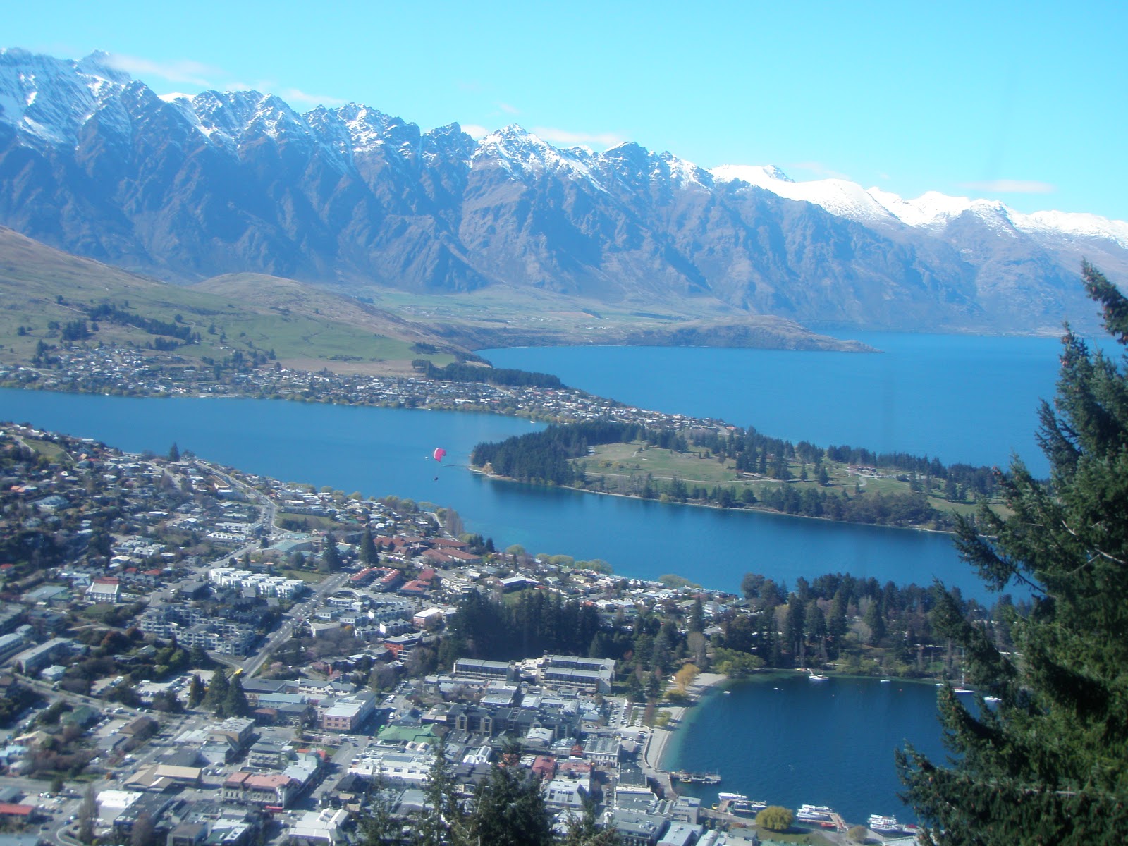
View of Queenstown from the Gondola
Day 4. Manapouri to Queenstown.

We packed up and drove on to Queenstown. We took the Skyline Gondola up to the top of Bob's Peak and then continued hiking on the Ben Lommond Track to the saddle and then on towards the summit. Parts of the trail were covered in snow, other in slush, and quite a bit in some very slippery mud. All of us overdressed and were way too warm (taking off layers as we went) while walking. We stopped and had a picnic lunch. The views over Queenstown, the lake and nearby mountain ranges were spectacular on this beautiful day. We continued on after the saddle and a bit further as a group.
Jenny's parents (Ben Lommond summit in background)


David and Jenny attempted to climb the summit (extremely steep and covered with snow, hanging onto rocks and clumps of grass) and looked over the ridge but did not make it to the summit. However there was no marked trail (possibly due to the snow).

We all made it back safely. David then went tandem paragliding (incidentally forgetting to give up the car keys). We all watched the various paragliders, solo and tandems land in a nearby football field and were able to watch David's descent. We spent the night at the Top 10 Holiday Park- Creeksyde which had double paned glass (a first) and was very environmentally friendly (truly) with newspaper scrap bags for composting food waste in their worm farm. 


Day 5. Queenstown to Franz Josef.

We left Queenstown and spent a good part of the day driving to Franz Josef (Glacier Country), taking the scenic and very windy route over the mountains (Crown Range) instead of the main highway. We then made our way to the West Coast and out to the ocean, following it northeast along the coast and inland to the Glaciers. The sand on the west coast is very grey and most of the beaches we came across were covered in pebbles (different sizes depending on the beach).


The West Coast is very rugged and reminded us of coastlines in Oregon, Washington (Olympic National Park) and California (Big Sur). We stopped at the beach for a brief walk around and at a lookout to take some photos.
Knights Point Lookout -looking North

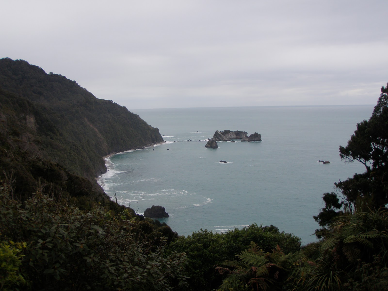
Knights Point Lookout -looking South
We also stopped at Lake Matheson outside the town of Fox Glacier to do a walk around the lake and take in the local rain forest. The lake was very still so we had beautiful reflections of the mountains.

We came across a lot of sheep and young lambs while in New Zealand (more than any of us had seen in our lifetimes combined). There are approximately 31 million sheep in New Zealand and just over 4 million people. This photo was taken outside the town of Fox Glacier (courtesy of Sandy).

We stopped in Fox Glacier to book our half day guided glacier walk for the next day (very glad we did this in advance) before heading to our accommodation in the town of Franz Josef where we spent the next two nights.


Day 6. Fox Glacier and Gillespies Beach

Kea (alpine parrot) with walking poles, Glacier (background)
In the morning we headed back into Fox Glacier (town) and were outfitted with heavy socks, boats, and other outwear (hats, gloves, jackets etc) if you wanted them and crampons (packed with) for walking on the ice. We were bussed out to the parking lot near Fox Glacier and then were led by our guide, Dave, up the walking track. Before getting onto Fox Glacier we were offered walking poles and fitted our boots with crampons. We had beautiful clear sunny weather while on the glacier.


We walked along stairs cut into ice by our guide and walked into a couple of moulins and into a crevasse which gave us a much better and look into the glacier and the ice (see photos below). It was really cool to be up so close to the ice. You could hear the glacier move and the water moving through the glacier and see the blue color of the ice come through in some of the features.


Ice steps being cleared by guide
Mountain Woman
Walking in a crevasse

The clouds were rolling into the mountains and we could tell it was raining (see below). We felt a few drops of rain and it was already time for our group to finish up on the glacier.
We all made it back to the bus and they drove a few minutes before the torrential downpours began.  Lucky for us we were nice and dry. We decided to head west to the ocean and visit Gillespies Beach as it was sunny in that direction. Fortunately for us the weather held and we stayed nice and dry and enjoyed a beautiful afternoon. The beach was full of nice smooth skipping stones which Richard worked on returning to the ocean (definitely at least a lifetime's supply). 
Gillespies Beach
Group- Old Mining Tunnel
Beach Pebbles


Day 7. Franz Josef to Punakaiki 
Franz Josef Glacier
In the morning we walked on a trail to get a closer look at Franz Josef Glacier, before continuing our drive north. We stopped in Hokitika to walk around, visit the beach briefly and stores selling jade (which can be found locally and some of which is also carved locally). We made it up to Punakaiki (Pancake Rocks) and Blow Holes (~1hr north of Greymouth) in time for the high tide. This is supposed to be the best time for viewing the blow holes, however as the sea was as calm as glass there wasn't much spray on the rocks. Loud thundering noises could be heard as the waves cut in and under the rocks which was really cool. The rocks themselves, composed of even layers of sedimentary rocks (previously at the bottom of the sea) were like nothing else we had seen before. The area around the pancake rocks was heavily vegetated with native flax and Nikau Palm trees.
Pancake Rocks
West Coast
Nikau Palms & Flax

After dinner the group split with the guys staying home and walking down to the local beach. The gals drove about an hour north to Cape Foulwind to visit the fur seal colony there and take in the sunset. Luckily unlike the name, the coast was quite calm that evening and we did see some fur seals (8-12). At sunset we had the beach entirely to ourselves.


Cape Foulwind
The twins
Mother & Daughter


Pebbles- Truman Beach
Day 8. Greymouth to Christchurch.

After breakfast we headed down to the nearest beach (8 min walk from where we were staying) called Truman beach which was covered is very small pebbles. There were some interesting rock formations and caves on the beach as well. 
Cave and waterfall- Truman beach
Then we drove back to Greymouth and attended church there, followed by a brewery tour at Monteith's Brewing Company and cider and beer tastings. Afterwards we headed to the beach and had lunch on the rocks before dropping off the rental car and boarding the Tranz Alpine Scenic Train. The ~4 hour train ride took us through some spectacular country and it was nice break from driving as Jenny and David were the sole drivers for the trip. We arrived in Christchurch where the weather was much cooler than when we left hours earlier. Just on the shuttle drive from the airport to our hotel and our few block walk to dinner we could see that Christchurch is still rebuilding from the devastating earthquakes from February 2011 though we didn't get a chance to visit the hardest hit central downtown area which still is contained within an exclusion zone.


Day 9. Goodbyes
We were up quite early to catch our 4:30am shuttle to the airport for our 7am flight back to Brisbane. Jenny's family's flights didn't depart for a few hours later to Auckland but we all took the shuttle together. It was too early for them to check in for their flight so we hung out and said our goodbyes before we had to separate to go through security. It was great for Jenny to see her family as it has been nearly 16 months since she saw them last (during her last trip to MN). Overall, it was an excellent trip and a good but brief tour around the South Island of New Zealand. We would highly recommend it to anyone who has not visited yet.

Monday, June 11, 2012

Whitsundays and Great Barrier Reef (trip #3)

Hi friends an family, we apologize for the greater than six month delay in our blog. We will start by catching up from our most recent trip last week (June 3rd- 6th) and then try to fill in the intervening months.
Sunset overlooking Airlie Beach Marina (Courtesy of Casey)
Whitehaven Beach
We were fortunate to have our third group of visitors from the USA this past week. Casey and Josh are friends of ours from university. As we have been to the Great Barrier Reef twice in the past year with different groups, first to the outer reef outside Cairns in July 2011 and then to the reef outside 1770/Agnes Waters in March 2012 we decided to pick a new location in the middle. As the Great Barrier Reef is 2600 kilometers (1600 miles) long with over 2900 separate reefs so there is a lot of reef to explore.

On Sunday we flew to Proserpine airport and took a shuttle bus into the town of Airlie Beach. We spent three nights at Marina Shores in one of their two bedroom apartments overlooking the marina. We had picture perfect weather the entire time.

In the clear water of Whitehaven Beach

On Monday we sailed out to Whitehaven Beach on the catamaran Camira with Cruise Whitsundays. The 7km (4.3 mile) beach stretches in a long crescent. The sand is very pure silica (98% pure) and white like snow. Unfortunately due to the full moon and extra high tides there were large quantities of leaves left as the tide receded taking away from how white the sand actually is. The water was very clear and calm and we could see fish swimming around us as well. We had a nice time playing in the water, swimming, and strolling along the beach.


The group on Camira return trip to Airlie at sunset
We also stopped for some snorkeling in Hook Passage which is a fringing reef off Hook Island on the way back to Airlie Beach. The water visibility wasn't very good but there was a variety of corals (including soft corals) and fish present. There was also a sea turtle hanging out on the reef which we were able to visit as well.

At Reefworld on the Great Barrier Reef
On Tuesday we headed out to the Great Barrier Reef with tour operator Fantasea out to their Reefworld pontoon. This pontoon has been anchored for the past 30 years near the edge of Hardy Reef.

First we did a glass bottomed boat tour on their "semi-submersible" to get a good look at the fish and corals present on the reef (while staying dry). A staff member was present to explain what fish and coral species were were seeing and to answer our questions.


Next we suited up in our aqua stinger suits (except David) and wetsuits. As it is winter here in Australia it isn't stinger season but there is a remote chance of encountering a stinger (jellyfish) and we thought they would keep us a bit warmer as well. The water temperature was 23C (73F) but you did get cool after a bit.

We started off with a guided snorkel tour where the four of us were with a marine biologist. We got to see a variety of fish including Pink Anemone Fish (relatives of Nemo), Christmas Tree Worms, and a Pink-Faced Devil Fish (if I recall correctly) that was very protective of its territory of algae on the reef. Our guide tossed a shell in the Devil Fish's area and it promptly picked it up and removed it out of the way which was very cool to watch.
Barrier Reef Anemone Fish and Anemones
We continued snorkeling on our own for a while and saw a variety of fish, corals (mostly hard corals) and anemones. David was successful in capturing some excellent photos with our underwater camera (see left and below).

Most of the fish were found along the edge/shelf of the reef as this is the growing edge of the reef. However, some like the Devil Fish and Parrotfish were present in the shallow water on top of the reef.


Parrotfish (males are brightly colored)
While we were snorkeling along the edge of the reef  a large school of Parrotfish were heading in the same direction so we were able to observe them for quite some time. Parrotfish nibble on the hard coral with their parrot-shaped beak (mouth) to get to the algae. You can actually hear the fish chomping on the coral underwater. They grind the coral and when the poop generate sand. One fish can generate up to 90kg (198lbs) of sand per year. We were told on our tour that parrot fish may be responsible for generating 15% of the sand in the ocean. 

Crocea (Boring) Clam (species)
The pontoon also had an underwater viewing area where you could observe fish that were swimming by as well. By the time our boat left many areas of the reef were beginning to become exposed during the low tide.

We had a great day out on the reef and this was the most fish we had observed in the three trips we have taken. Each area of the reef we have visited have been different with the types of coral and fish present.


Sunday, December 11, 2011

Some food adventures in Australia

I thought I would share some interesting food that we have tried during our time in Australia. Most of this is based on our weekly trips to the local farmer's market where we buy most of our fruits and vegetables. Produce at the farmer's market is often cheaper than the supermarket or the fruit and vegetable shops. There is also a much greater variety in product and prices and the ability to support the local growers.

Dragonfruit
The weather here in Queensland (the state we live in) is conducive to growing produce year round and there is quite a variety in local produce. You can purchase locally grown avocados and bananas year round. We purchased our first bananas in nearly nine months recently as cyclone Yasi (last February) had wiped out most of the banana crop in Australia (northern Queensland) and they were too expensive to buy with peak prices of  up to $18 per kilogram (2.2 lbs). I have recently seen prices as low as $1 per kilogram.

Seasonally we can get locally grown strawberries and pineapples. The pineapples are the best we have ever had being extremely sweet and juicy. They can also be quite inexpensive as well at $2-3 dollars per pineapple. Also grown in Queensland is a variety of tropical fruits and citrus as well as in cooler regions apples, grapes, and stone fruits (apricots, plums, peaches, cherries). Currently in season are stone fruits, as well as mangoes. Mangoes are one of our favorite fruits being incredibly sweet and juicy. Fortunately mangoes are now in abundance with people selling crates of them on the side of the road. We just split a mango for dessert after lunch today. Mangoes come in several varieties (Kensington Pride, Calypso, R2E2 and more) and sizes as large as a cantaloupe (known as rock melons here).

Cucumbers
Occasionally at the farmer's market we decide to try something new or different that we have never had. Today for example I didn't know what one of the items was that was being sold and was informed it is a cucumber. We bought one (the white one) but I think we'll prefer to stick to the more traditional varieties (see cucumber photo) as the seeds are much larger.

In previous farmer's market trips throughout the year we have purchased items such as persimmons and star fruit. Some of these items can be found in the supermarkets in Minnesota (and likely elsewhere) but I had not tried them before. Sampling of exotic fruits started with my roommates Amy and Sarah during our junior and senior years of college where we would pick up interesting fruit like a  pummelo (giant citrus like a mild grapefruit) from the supermarket and then "google" how to prepare and eat it.  Persimmons are quite common here when they are in season and quite good. It looks a bit like an orange tomato (similar to the Black Sapote, see photo) but is a sweet and juicy fruit that can be eaten just like an apple.

Back in February we started trying different fruit by purchasing a dragonfruit (see photo, top of page). This one has a translucent flesh (some have a pink flesh like the outside) with lots of small seeds. It was similar in texture to a kiwi fruit. It wasn't very sweet and didn't have too much flavor but we found that it went well with vanilla ice cream for dessert.

Custard Apple
We came across a really strange looking fruit called a custard apple. The fruit is light green with a leathery skin and very irregular shape with lots of bumps. One of my coworkers was telling me about them and how they tasted like fruit salad.
Custard Apple
We decided to give the custard apple a try and purchased this one and ate it back in April. The seeds are black and quite large (not edible). We then scooped out the white flesh and ate it. It did taste like fruit salad and did have a consistency similar to custard which was quite unexpected for a fruit.

Black Sapote
Black Sapote
My favorite farmer's market discovery so far is the Black Sapote (Chocolate Pudding Fruit) which is a species of persimmon. This fruit is native to eastern Mexico and Central America south to Colombia and is grown in the tropical region of northern Queensland. I had seen this unusual looking item at a couple of farmer's markets and decided to ask to person selling them about it. I purchased one and could not have been happier.  I let it ripen a few days on the counter until it became soft to the touch. From the photo you can see the brown flesh. Black sapote contained some large dark brown seeds (not seen in these photos) which I removed. I scooped out the flesh and put it in a bowl where I stirred it a bit. It does look quite a bit like chocolate pudding. It had a consistency like pudding a tasted a bit like chocolate though not very sweet. I had read online that you could sweeten it with a bit of honey or add some cinnamon or nutmeg. We decided to have some with the neopolitan ice cream we had on hand. It was delicious!


Black Sapote (Chocolate Pudding Fruit) on neapolitan ice cream
Black Sapote (Chocolate Pudding Fruit)


Within the past week we have also tried a few different foods from the supermarket shelves.

I was curious to find out whether "marshmallows"  here in Australia would be suitable to use with the graham crackers that are being sent to us (thanks Mom) to make smores. Marshmallows are not located in the baking section but in the candy isle next to the rest of the lollies (term for all candy not just lollipops). I just recently saw for the first time bags that contained all white marshmallows but that was after we had already purchased the standard pink and white variety. The marshmallows are much smaller than the standard large jet puffed marshmallows I was used to buying in the USA and have a bit of a crust on them that cracks when they receive any pressure. The pink ones were supposedly raspberry flavored and the white ones vanilla. I must say the flavor and texture is just not the same, a bit chalky as well and I don't plan on buying them again. Marshmallows are also available in swirl varieties with flavors such as strawberry, forest berry,wildberry, passionfruit, and caramel.


We also had purchased some vegemite flavored potato chips a while back and decide to try them out. For those not familiar with vegemite it is an Australian creation made from yeast extract. It is a very salty dark colored spread that is put (very thinly) on toast or crackers. It can be consumed for breakfast or I supposed any time of day. I must say I'm not a huge fan of vegemite but slightly prefer the flavor of promite (a similar type of product). However, like a good Australian we do have a jar of vegemite and do occasionally have it on buttered toast and is even better with a slice of cheddar cheese on top. If you are curious you can find vegemite in the USA but buy the smallest container you can find as most likely you  (like most Americans) will not like it. In October a new potato chip flavor, vegemite, was released by Smith's. The chips are actually quite good, a little bit of vegemite flavor but not too strong. We tried them as they were only a $1.00 at the supermarket and were curious about what this novelty item would take like. The fact that we actually liked the chips may mean that we are becoming more Australian. If you are coming to visit or would like to try them they have only released these chips for 12 weeks (unless they make them a permanent addition) and I would need to go out and search to see if there any are left in the supermarket.

Monday, October 10, 2011

Hervey Bay weekend trip

Bundaberg Barrel
For our 6th anniversary we took a weekend trip to Hervey Bay located 4.5 hours north of the Gold Coast. We had one night hotel free courtesy of a bank promotion that Jenny won. We drove up Friday night stopping for dinner in Gympie arriving quite late to our hotel. Saturday the weather turned into heavy thunderstorms with torrential rains. We hopped in our car and stopped at a local fruit stand in the country selling pineapples. We talked with the owner/grower and she explained to us how pineapples are grown and the different varieties of pineapples. She helped us pick out a pineapple which had been harvested just down the road. The pineapple was quite delicious. We learned from her that the top of the pineapple can be planted in the ground to grow a new plant.

We continued driving north (1hr 45 minutes) until we reached Bundaberg. This area is surrounded by sugar cane and ginger fields and is known for its cane sugar, Bundaberg Rum, and other nonalcoholic beverages, namely ginger beer. We stopped at the Bundaberg Barrel where we did the interactive tour to learn how they brew ginger beer, followed by a sampling of their sodas. We purchased a variety pack to bring home including flavors such as guava, apple ale, and a burgundy creaming soda.

We then drove down the road to the Bundaberg Distillery where they make Bundaberg Rum. Unfortunately we had just missed that last tour of the factory for the day. We checked out some of the displays containing history and memorabilia. We will have to make the tour on another visit as the factory (across the street) looked quite interesting. The tour will also address our question of why they have a polar bear on the rum bottles.

By this time of the afternoon the weather had cleared up and we made our way to the Bundaberg Botanic Gardens. Located amidst the gardens is the Hinkler Hall of Aviation, a museum dedicated to Bert Hinkler who was born here. The museum was brand new and very well done. He was the first pilot to cross the South Atlantic and to fly from England to Australia. His home in England was painstakingly dismantled and reassembled, brick by brick, in the botanic gardens and can be toured as part of the museum. 
Hinkler House

We returned to Hervey Bay for dinner and the next morning headed out to Fraser Island. Most people who come to Hervey Bay come to visit Fraser Island, go whale watching to see the Humpback whales as the migrate past between August and November, or other activities on the water. We lucked out that the weather was perfect, not a cloud in sight as we departed the Hervey Bay airport. We were in a small airplane that seats ten people, with just us and a young couple from Ireland as passengers.

Fraser Island is the world's largest sand island stretching 120 kilometres (75 miles) and its width is approximately 24 kilometres (15 miles). It is a world heritage listed site. There are two ways to reach the island (by ferry or less commonly by plane). Once on the island the only way to get around is by 4WD or foot. The main highway is the beach which is quite wide and flat and also serves as the runway for small planes.

Fraser Island (East Coast)
The plane dropped us off on the beach near the trail head to Lake Wabby, one of several freshwater lakes. We hiked the couple of miles out there and were the first to arrive having the lake all to ourselves. It was very peaceful just listening to the birds and watching the catfish swim around. The other couple arrived shortly after and then group after group of young adults and a few families.
Lake Wabby (view from plane)


The water was amazingly clear and extremely soft to the touch. The lake is not fed by any streams and has no outlet. The lake is being encroached on by a sand dune by about a meter (~3 feet) per year and will someday disappear.

Lake Wabby from shore (with encroaching dune)
We spent several hours by the lake sitting in the sand, swimming, and lying out in the sun. We hiked to a nearby lookout to get a better view of the lake and the island. We returned back to the coast (the main highway) and walked along the surf the couple of miles to the resort for lunch. While waiting for our return flight we sat watching the waves. The signs warned us not to go swimming because of the dangerous current and tides and because of sharks. It doesn't appear that there are any patrolled beaches with surf life savers on the island probably due to the unsafe conditions.

On the flights to and from the island over Hervey Bay we could see wildlife such as dolphins, dugongs (similar to manatees), and sea turtles. It was a beautiful day on the island and we were very glad we changed our reservation from Saturday to Sunday otherwise we would have gotten quite soaked in the rain.

Lake Wabby lower right, Pacific Ocean behind us
Now that we have had a small taste of what Fraser Island is like we hope to make a return trip and rent a 4WD to do some more exploring and camping. Maybe then we will spot some of the wild dingoes (the purest in Australia) as they haven't interbred with domestic dogs on the mainland.

Wednesday, August 17, 2011

Adventures in Far North Queensland: Coral, Cassowaries, and Crocodiles


Mangrove Orchard @ Winery
Our first vacation together flying within Australia. We flew with Jenny's brother from Brisbane to Cairns (gateway to the Great Barrier Reef). It is just over a 2 hour flight from Brisbane. It was a short trip arriving Saturday afternoon and leaving very early on Wednesday.

Sunday we attended church at the Cairns Cathedral which has amazing stain glass windows with the creation story wrapping around the church. It was very cool to see the images emerge as the sun rose illuminating them for us to see. We started the day driving around the Atherton Tablelands the area inland (west of Cairns) checking out some of the beautiful waterfalls in the area. We drove by quite a few dairies and were lucky enough to have spotted a Lumholtz Tree Kangaroo which another group had already found. The weather wasn't all that great with misting rain. We stopped at a dairy museum in Malanda which David toured and quite enjoyed. Later we stopped and sampled some mango wine and liquors. David, our chauffeur, drove us to Chillagoe which is considered an Outback town. In Far North Queensland, it is not very far to get to the outback (2-3 hour drive), however from where we live in Southeast Queensland it is at least a 10 hour drive. We explored some of the local rock formations and termite mounds and passed many cattle and a few road trains (semi trucks with three trailers or more) on the way.

Giant Clam
On Monday we spent the day on the reef. The Great Barrier Reef is immense stretching over 2600km (1600 miles). From Cairns it is a couple hour boat ride to the outer reef (recommended over the close Green Island). We visited Michaelmas Cay and Paradise Reef on our tour. The coral and variety of coral was quite amazing but I have seen greater numbers and variety of fish in the
Anenome fish
Caribbean and also likely in Julian Rocks. There are also giant clams up to 4 feet across (or even larger) which were amazing. The water wasn't cold but we still rented wet suits to keep us a bit more comfortable in the water. The water clarity was good and we didn't have to worry about any box jellies or other stinging jellies (see warning sign below) at this time of year (winter in the southern hemisphere). David and Jenny stuck to snorkeling but introductory dives and glass bottom boat tours are also available. Jenny's brother did two introductory dives and saw huge sea turtles on his first dive. Diving will hopefully be tried out in our future trips to the reef.

Cow Bay Beach
We spent Tuesday heading further north into the Daintree National Park (about 1.5 hour drive north of Cairns) which is a world heritage listed tropical rainforest. On the way we stopped and walked along the beach in Newell. Justin and Jenny managed to loose a "returning" plastic boomerang to the ocean where it sunk. However upon our return walk quite a while later it had, quite to our surprise, washed onto shore . We continued north and crossed the Daintree River using its cable run ferry (the only way to cross) and then made a stop in Cow Bay to take in the beautiful beach and scenery.

We stopped and did a walk in the rainforest in search of Cassowaries (large emu like birds where the males have bright blue and red coloring and a bony plate on top of their head, see photo below). On the way north to Cape Tribulation (as far as you can go in a two wheel drive vehicle) we did come
Male Cassowary @ Zoo
across a juvenile or female cassowary running on the side of the road. We got out at Cape Tribulation where the reef and rainforest meet for a brief look around before turning around. After we crossed the ferry again we participated in a sunset/evening wildlife watching tour on the Daintree River. We choose to go with Dan Irby's Mangrove Adventures and we were not disappointed. We saw at least five salt water crocodiles, a tree frog, and many different birds and were lucky enough that the clouds cleared enough for some star gazing to take in the southern cross and scorpio constellations. We stopped for dinner in Port Douglas where there was a variety of restaurants to choose from. The next morning we were up quite early for our 5:30am flight back to Brisbane.
Saltwater Crocodile (Daintree River)

Wednesday, January 12, 2011

Floods

As many of you know by now parts of Australia have been experiencing severe flooding, but Jenny and I are safe. The floods first hit the city of Rockhampton which is an eight hour drive north of here and with rains that have been continuing for weeks more and more areas are being affected. Queensland, the state of Australia where we live has been experiencing record breaking rainfall and now the ground is saturated, dams are full and when it rains it just runs to the rivers. With it raining almost everyday we are seeing a lot more communities afflicted with flooding. Last weekend it was the city of Gympie about 4 hours north of us and now it is hitting Brisbane about 45 minutes north. For me this means I cannot travel out to farms to work as most every major road is either underwater or severely damaged. Again Jenny and I are safe as the gold coast is not built around any sizable river the area we live in has some elevation, but we are praying for the thousands of people who are being displaced. We want to help out the government and red cross are not looking for volunteers yet.

Saturday, January 1, 2011

Snorkeling at Julian Rocks

New Year's Day we drove to Byron Bay and went on a snorkeling tour at Julian Rocks Marine Park. We had just purchased snorkeling gear and reserved the tour with money from my parents for Christmas. The weather wasn't the nicest as the sky was completely covered with clouds and a light mist of rain was falling. I guess the rain didn't really matter as we were going to get wet completely in a matter of minutes. The tour operator drove us to the beach where the boats were put in. The ride was a bit rough and exhilarating with swells about 3 feet or more. The marine reserve is about 2.5 kilometers (~1.5 miles)  from the mainland coast off Byron Bay. More than 500 tropical and temperate fish species are known to found within the reserve. As soon as we got in the water you could see fish everywhere. The water was actually was quite deep up to 30 feet in places near the rocks which are remains of former volcanoes. Unfortunately the visibility was not very good. The divers in our group were able to go much deeper and saw a loggerhead turtle that was at least 70 years old. We did spot a carpet shark on the ocean floor below us but it was nothing to be worried about. It was very cool to swim with and be completely surrounded by schools of fish. Julian Rocks is considered a top ten dive location in Australia. Although it lacks in coral, the fish are amazing and we were told that the fish here much better than what we would see in the Great Barrier Reef. We will need to spend some more time breaking in our new snorkeling gear and plan to return here and head to the Great Barrier Reef for some more snorkeling. Unfortunately the underwater photos did not turn out very well because of poor visibility. We decided to cut our road trip short and head home stopping for lunch near the ocean in Kingscliff. Since Byron Bay is less than a 90 minute drive from where we live we decided to come back to the area and explore the numerous national parks at another time when the weather is nicer.